

Table of Contents
Laramie …………………………………………. 1
Union Pacific Railroad – Sherman Hill ………………. 6
Route to Perkins …………………………………. 10
Union Pacific north of Laramie …………………….. 16
Other railroads in Albany County …………………… 21
Laramie Hahns Peak and Pacific …………………….. 22
Rail/Trail in the Medicine Bow Mountains ……………. 27
Map 1 – overview of Albany County and its railroads (Digital data used to create the maps in this brochure was graciously provided by Alan J. Frank, Office of GIS, Albany County, Wyoming)
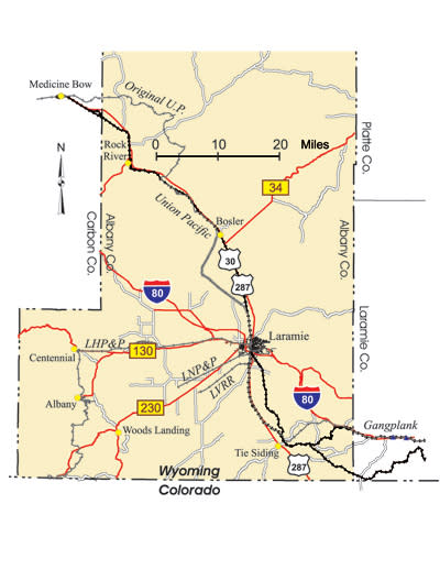
Laramie
This tour begins in Laramie, which was founded in the spring of 1868 with the arrival of the Union Pacific railroad. The U.P. was on its epic drive towards Promontory Summit, Utah, where it would meet the Central Pacific on May 10, 1869, to complete the nation’s first Transcontinental Railroad. See Map 2 on page 2 for the locations of some of the railroad sites around Laramie.
Laramie Railroad Depot, at 1st St. and Kearney St. This elegant structure was built in 1924 to replace a former station and hotel, which burned in 1917. It has been fully restored and serves as a museum and community center. The depot’s waiting area can be rented for parties, weddings and other events. It is listed on the National Register of Historic Places as part of historic downtown Laramie.
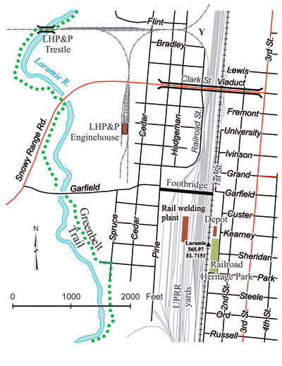
Map 2 – Railroad sites around Laramie
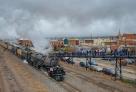
Just south of the Depot is Railroad Heritage Park which features a “snow train” consisting of a wedge snow plow, steam engine, bunk car and a caboose. It is dedicated to the railroad men and women who kept the tracks free of snow, allowing passenger and freight trains to continue operating through fierce, Wyoming winters.
The U.P. Laramie yard tracks are still intact, but are now rarely used – a lone SD40-2 is the only regularly used motive power. It was once a far different place when the mighty steam engines of days gone by roared in and out of Laramie. Big Boys, Challengers, and 9000 series 4-12-2 engines were a common sight taking on coal and water, being turned on the 135 foot turntable and serviced in the 29 stall roundhouse.
Footbridge. This bridge, built in 1929, provides an unparalleled vantage point for watching trains as they pass through Laramie. The original 1868 mainline is the seventh track from the east end of the bridge. A brochure describing the sights visible from the bridge is available in the drop box at the east base of the bridge. This bridge is also listed on the National Register of Historic Places as part of historic downtown Laramie.
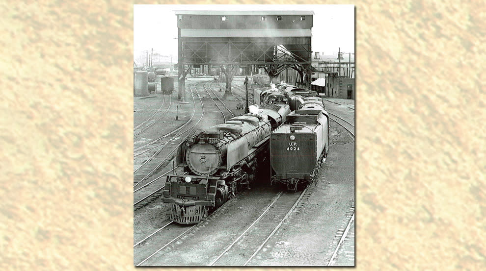
Fig. 1 – U.P. Challengers 3967 and 3950 leave the Laramie coaling facility while Big Boy 4024 and another massive engine approach it in June, 1952. The photo was taken from the middle of the footbridge and faces south.
Robert P. Olmsted Collection, American Heritage Center, University of Wyoming
Rail welding plant. The plant takes 80-foot rails and butt-welds them together into quarter mile lengths. Forty such lengths are loaded onto specially adapted cars and distributed across the Union Pacific system to provide the smooth running characteristics of continuous rail.
LHP&P engine house. The Laramie, Hahns Peak & Pacific Railway used this structure, now a cabinet shop, as its engine house.
LHP&P trestle. This trestle was built in 1962 after its predecessor burned. It is now part of the Laramie Greenbelt hiking/biking trail.
Site of former tie plant. A Union Pacific tie plant operated until the early 1980s, when it was closed due to environmental concerns. While in operation it boasted a 29.5” narrow gauge tramway for shuffling cars loaded with ties in and out of the creosote treatment buildings.
Quarry lines. A U.P. spur ran from the main line, across 3rd Street and then along the north side of the I-80 access ramp fence to quarries located north of Grand Avenue on Laramie’s east side. Most of the line was abandoned in the 1940s, but the portion along the I-80 fence line remained until the mid-1970s. Some ties are still in place along this stretch. Sidings once ran from this spur to service a former bulk oil distributor located on the west side of 3rd Street.
A narrow gauge tramway terminated near 3rd St. and Boswell Dr. at a plaster mill. The tramway followed Spring Creek east for just over a mile then turned south into a gypsum quarry. The roadbed for the line is still visible on the south side of Spring Creek, especially just east of 17th Street where it drops down a gentle grade to the former quarry site. A few ties, some with spikes, are still present in the former quarry site.

Fig. 2 – A narrow gauge Davenport engine pulls a string of cars loaded with treated ties from the U.P. tie plant, 1936.
H. Svenson photo, Ludwig-Svenson Studio Collection, American Heritage Center, University of Wyoming
Union Pacific Railroad - Sherman Hill (SH)
The driving tour of the Union Pacific across Sherman Hill begins 35 miles east of Laramie. We’ll start at The Gangplank, a geologic feature that provided an exceptionally easy railroad crossing of the Laramie Mountains between Cheyenne and Laramie.
Take I-80 east from Laramie to the truck rest area at exit 345.
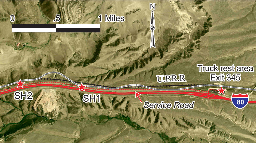
Map 4 – Gangplank and vicinity Air photo base (2006 NAIP DOQ) courtesy of Wyoming Geographic Information Science Center, University of Wyoming
A sign showing an artist’s rendition of The Gangplank is located at the east end of the rest area. Unfortunately, at this location, you can’t see The Gangplank! The sign’s text tells its geologic story, but fails to address its far more important historical significance: if The Gangplank did not exist, or had not been discovered, the Union Pacific would have probably built its tracks to Fort Collins and then north onto the Laramie Plains following the route of modern day U.S. 287. This would have drastically altered Wyoming’s history and geography, and the city of Cheyenne might not exist at all.
The current mainline of the Union Pacific lies 200 feet to the north, just on the other side of the small hill.
Immediately upon leaving the rest area, note the embankment to your north – it is a remnant of the original U.P. grade.
Follow the frontage road (Old U.S. 30) west for about 1.5 miles.
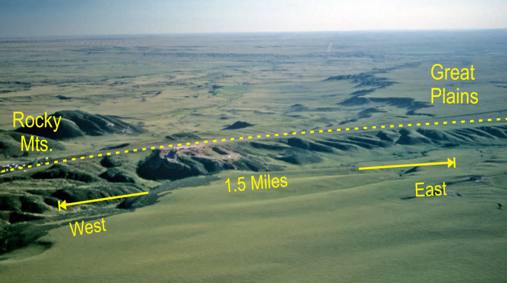
Fig. 3 – The Gangplank forms a bridge between the Great Plains and the Rocky Mountains. The dashed line marks the location of the Union Pacific tracks and I-80 in this view looking north-northeast. — L. Ostresh, 1986
Stop SH1 – Remnant Fill and Cut.
Until 2005, The Gangplank sign, now at the truck stop, was located here at an I-80 pull over [GPS] (see p. 29 for GPS coordinates). This location gives the visitor a fine view of the valleys to the north and south which define The Gangplank. To the north of the railroad are a fill and cut which were part of the original U.P. route on The Gangplank. The modern right-of-way dates from the early 1900s and avoids slight bends in the original alignment, permitting higher train speeds. However, the modern line only reduces the twenty miles distance between Cheyenne and Buford by 600 feet.
Continue along the frontage road west for .5 miles to the crest of the hill.
Stop SH2 – Gangplank view and ballast quarry. This is the tip of the arrowhead-shaped Gangplank and provides another fine view [GPS]. Here you can put one foot on the stratified rocks of the Great Plains and the other on the granite of the Rocky Mountains. The large quarry to the west is operated by Martin Marietta Materials and provides granite ballast for the Union Pacific and Burlington Northern Santa Fe railroads.
Continue west on the service road. As you descend the hill, look north to see the fill portrayed in Figure 4 on page 8 [GPS].
Take the on ramp to I-80 west toward Laramie; drive west, take the Buford exit (335), and drive to the east side of the service station parking lot.
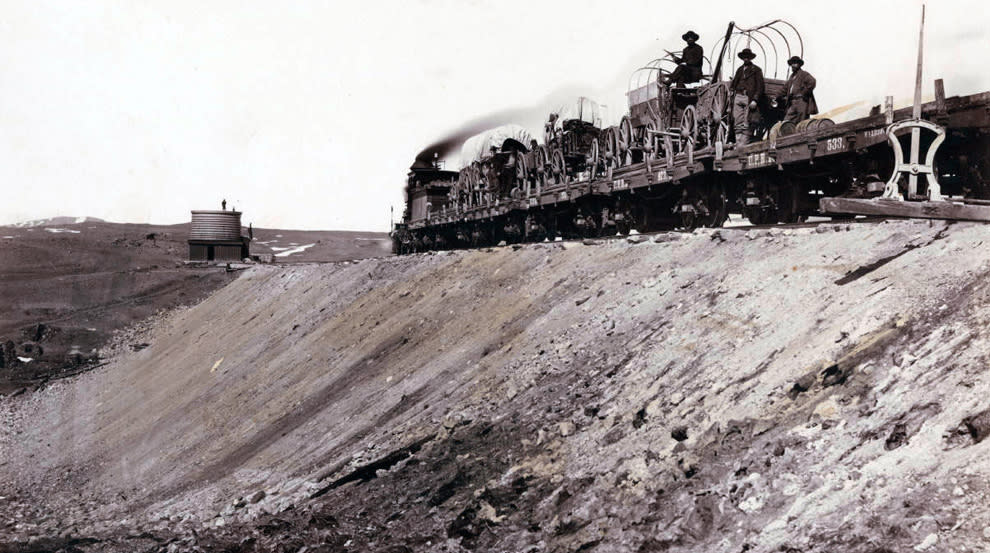
Fig. 4 – The U.P. track builders are heading west from the big fill just west of The Gangplank in this 1867-68 photo.
Photo by A.J. Russell, Beinecke Rare Book and Manuscript Library, Yale University
Stop SH3 – Buford. The embankment underneath the fence that heads southeast is part of the original U.P. railroad [GPS]. The modern mainline is 600 feet south, and the tracks to the east have some of the steepest grades on the U.P., 1.58%. This area was once a working quarry that provided “Sherman Granite” for much of the U.P.
Return to I-80 and head west. The interstate between here and the next exit is built directly atop the original U.P. right of way. Take the Tree Rock exit on the left (333), and read the signs about Tree Rock, the railroad, Lincoln Highway, and nearby Vedauwoo rocks (Stop SH4).
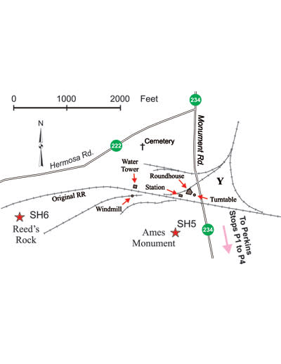
Map 6 – Ames Monument and Old Sherman
Return to I-80; head west and take the Vedauwoo exit (329). Follow Monument Rd. south to Ames Monument.
Stop SH5 – Ames Monument.
Completed by the U.P. in 1882 at a cost of $65,000, this 60-foot high granite pyramid marks the highest elevation (8,247 feet) on the original transcontinental route. The monument is a memorial to the Ames brothers, Oakes (1804-1873) and Oliver (1807-1877), who were instrumental in the construction of the first transcontinental railroad. The monument was designed by the distinguished American architect Henry Hobson Richardson, and the bas-relief medallions of the Ames brothers were created by the prominent American sculptor, Augustus Saint-Gaudens.
As you stand on the hill at the base of the Ames Monument, you can see remnants of the old railroad grades. The foundations of the round house, turntable [GPS], second station, and water tank are also easily found.
From the Ames Monument, the tour continues by following Monument and Pumpkin Vine Roads to Perkins on U.P. main track #3 (see Map 7 on page 10). We have designed the tour to take you to Perkins and then return to Ames Monument, thence to Hermosa Junction, but you may prefer to drive some other route.
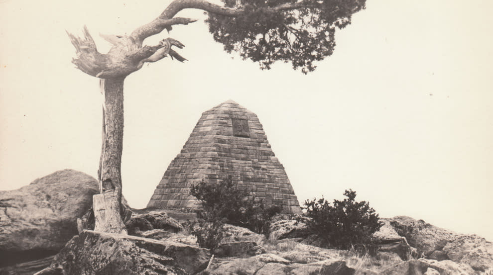
Fig. 5 – The Ames Monument. Postcard ca. 1940s.
Route to Perkins (P)
In 1901, under the direction of Edward H. Harriman, the Union Pacific re-routed its line over Sherman Hill. The town of Sherman was abandoned, and as a result, the Ames Monument no longer stood along the main line. The new line saved 234 feet in elevation, but was not any shorter. The new alignment was costly and involved the construction of a huge fill plus an 1,800 foot tunnel.
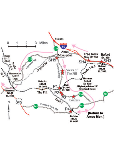
Follow Monument Road south about 1.5 miles to overlooks where you can view the route taken by the modern Union Pacific across Sherman Hill [GPS]. “The Fill” is visible to the southwest. Continue south on Monument Road to Dale Creek grade crossing.
Stop P1 – Dale Crossing.
Be extremely careful crossing the tracks here! High speed trains are frequent and can arrive with little warning. This is an excellent place to photograph the modern Union Pacific trains in action.
Continue on Monument Road for about .4 miles.
Stops P2 and P3 – Views of Track #3. To the southwest you will have a glimpse of U.P. track #3 on a high fill [GPS]. Track #3 was built in 1951 and is primarily used for westbound trains. Its ruling grade is .83%, much less than the 1.51% grades on tracks #1 and #2.
Track #3 not only has high fills, but it also has very deep cuts. Unfortunately, there is no public access where you can see the deepest cut, 120 feet from track to top.
Continue on Monument Road to its junction with Pumpkin Vine Road. Turn right and follow Pumpkin Vine Road for
2.5 miles to Perkins.
Stop P4 – Perkins. Perkins is on Track #3 and is another favorite photography site. The culvert you drive through nicely frames the Mummy Range in Rocky Mountain National Park, Colorado, to the south.
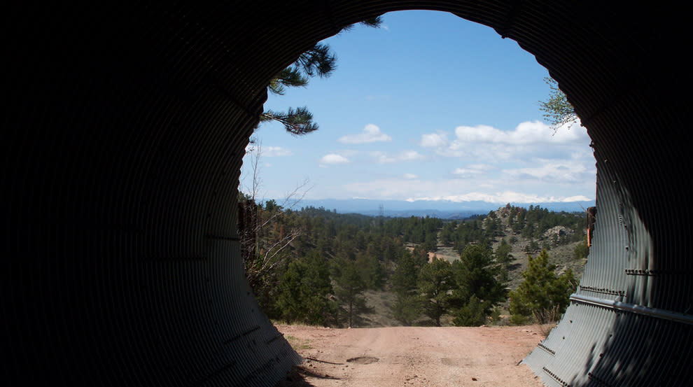
Fig. 6 – View of the Mummy Range from the county road through the culvert under Track 3 at Perkins. — L. Ostresh, 2010
Return to the junction of Monument Road and Hermosa Road. Follow Hermosa Road for approximately .7 miles.
Stop SH6 – Reed’s Rock (refer to Map 6 on page 9). The granite monolith to the south [GPS] was quarried and used to construct the Ames Monument. It is named for Samuel Reed, a surveyor for the Union Pacific from 1864 to 1869.
Continue west on Hermosa Road for about six miles to an overlook where you have a good view of Dale Creek Gorge.
Stop SH7 – View of Dale Creek Gorge [GPS]. The famous Dale Creek trestle was about a mile to the southeast. The trestle site is on privately owned land. Do not trespass!
Map 8 – Sites along Hermosa Road
There were three versions of the same trestle during the 30-some years of its existence, and all appeared very spindly!
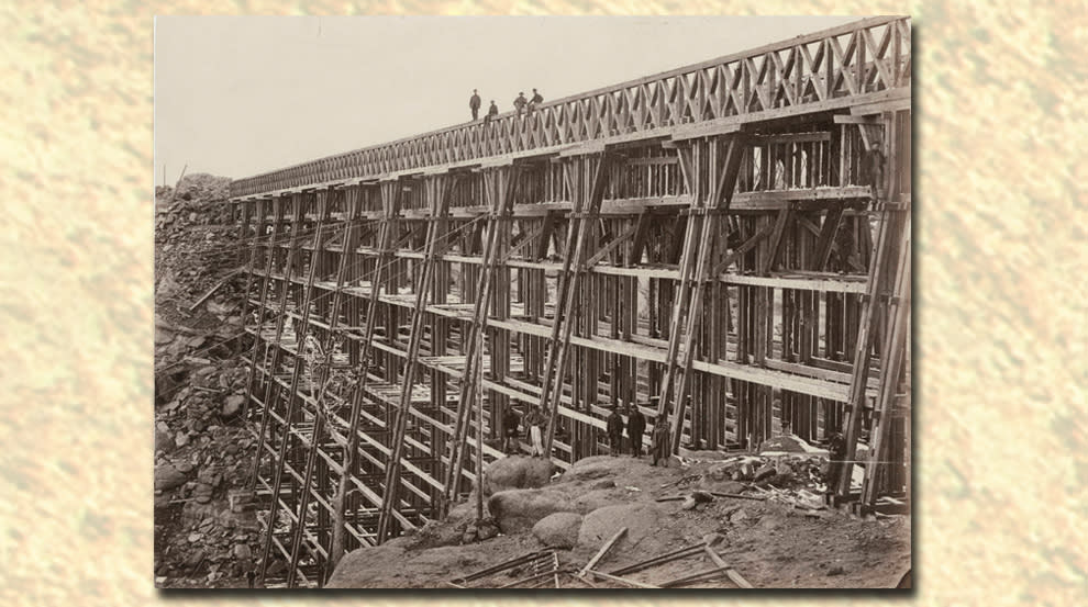
Fig. 7 – The first Dale Creek trestle, 1868-76. Photo by A. J. Russell, 1868, Beinecke Rare Book and Manuscript Library, Yale University

Fig. 8 – The second Dale Creek trestle, 1876-85. Union Pacific Railroad – Bridges – Dale Creek Photo File, American Heritage Center, University of Wyoming
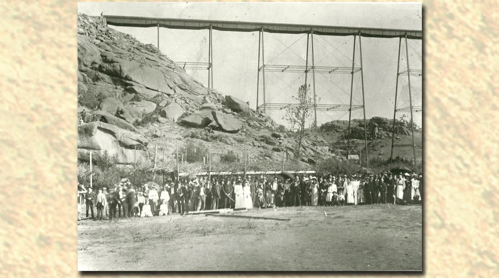
Fig. 9 – A group of Albany County picnickers pauses for a group photo at the base of the third Dale Creek trestle in the 1890s. The trestle served from 1885 to 1901. Unknown photographer, Jerry Hansen Collection
Continue on Hermosa Road for about 2.5 miles.
Stop SH8 – Cross original U.P. grade. The old roadbed crosses Hermosa Road here [GPS]. This was the original location of Tie Siding, which was a place where freight cars were loaded with ties, fence poles and wood harvested from the forests to the southwest. Note the width of the fill to the north, which is large enough to accommodate several sidings. A cemetery with many old graves is located nearby.
Continue on Hermosa Road for another .5 miles.
Stop SH9 – Hermosa. The road crosses the modern U.P. at grade here, and is a favorite place to take photos of trains slogging uphill and charging downhill. Be extremely cautious before crossing the railroad tracks!
The west portals of the 1800 feet long Hermosa tunnels are about 1.6 miles to the east, but are inaccessible because they are on private land. Do not trespass!
Continue west on Hermosa Road for about a mile to the intersection with U.S. 287. Then, follow 287 north toward Laramie.
Map 9 – Sites along U.S. 287 south of Laramie
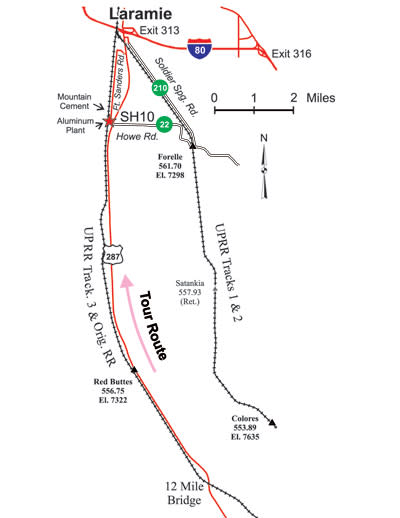
Stop SH10 – Aluminum plant and Mountain Cement. The abandoned aluminum plant [GPS] was built in the 1940s and closed in the 1960s. Mountain Cement [GPS] was built as Monolith Portland Cement in 1927 and still operates. Its vintage GP7, soon to be replaced by a GP10, is fun to watch shuffling cars in and out of the plant.
Union Pacific north of Laramie (LN)
Travel north on 3rd Street in Laramie (U.S. 30 and U.S. 287).
Former Stock Yards. Just north of the Curtis Street viaduct is the site of the former Union Pacific stock yards [GPS]. Some of the tracks remain and are occasionally used for storing railroad cars. The Curtis Street Bridge has pedestrian walkways, which offer striking views of the Laramie yards.
MM 327 to MM 326 on U.S. 30/287 – A PFE icing plant was located on the tracks to the west [GPS]. At one time it was the largest natural ice housing facility in the world. It was abandoned in the early 1960s and burned to the ground in 2009.
Just south of MM 321 on U.S. 30/287 take a left onto county road 51 (Howell Rd.) and zero your odometer. Cross the tracks and continue another .75 miles until the road angles to the northwest (about Mile 1.4). See Map 10.
Starting here, the road is built directly atop the original U.P. railroad grade. You can clearly see the undisturbed grade if you face southeast toward Laramie.
Map 10 – Howell Road sites
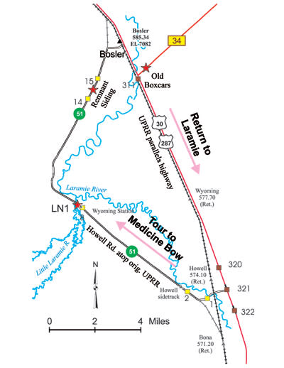
Stop LN1 – Wyoming, Wyoming. Continue atop the old roadbed to Mile 8 [GPS]. This is the site of the former Wyoming, Wyoming, station located where the Big Laramie and Little Laramie rivers join. Further along the road climbs the bluffs to the north – this is the only grade on the entire original line between Laramie and Bosler and it is less than 1%. The original alignment is about three miles longer than the present one, but – other than this grade – required no cuts or fills and was essentially flat.
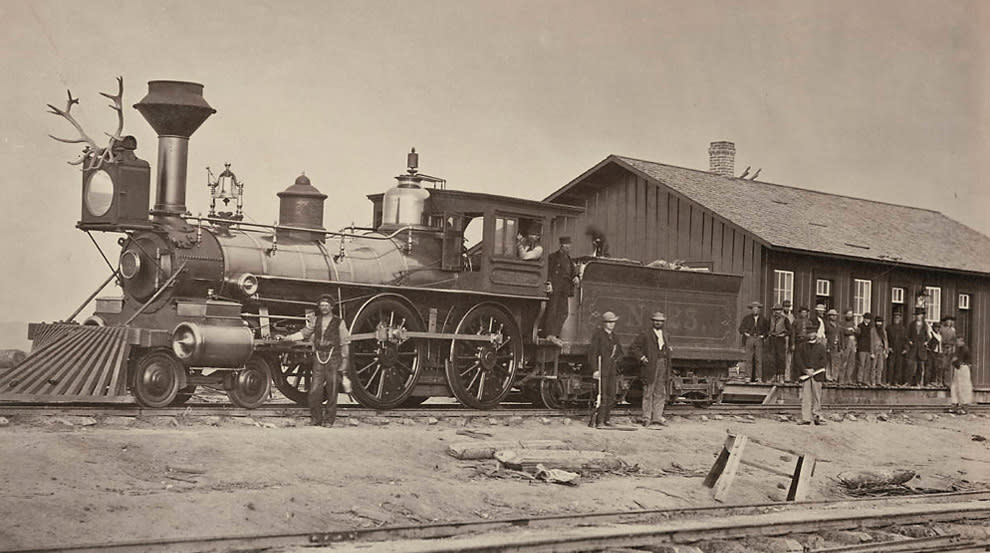
Fig. 10 – Wyoming Station, ca. 1868. Note the antlers on the headlamp. Photo by A.J. Russell, Beinecke Rare Book and Manuscript Library, Yale University
To the east of the road between Miles 14 and 15 are some former sidings [GPS]. Just north of Bosler the original alignment and present alignment join.
Continue north on U.S. 30/287.
The mainline of the Union Pacific is just to the west of the highway. From MM 308 to about MM 304 the current railroad is atop the original, but after this, the original weaves around the hills and valleys. Between MM 302 and 301 the original roadbed is very close to the highway, disappearing under the present railroad at Lookout siding [GPS]. The original Lookout station was further northwest by approximately two miles.
At MM 296 the original railroad veers sharply to the east and crosses the highway [GPS] as it begins to follow Meiser Creek (originally Miser Creek). It will not rejoin the present railroad until it reaches Medicine Bow. The original roadbed is 12 miles longer between here and Medicine Bow than the current one, the greatest disparity in distances between old and new for the entire line from Omaha to Ogden.
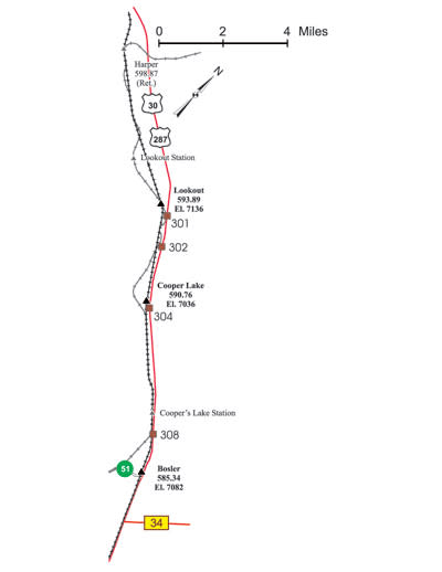
Map 11 – Lookout and vicinity
Access to the original mainline is limited because it is on private land, but views are available on two county roads, Fetterman Road and Marshall Road (see Map 12).
Between MM 294 and MM 293 the highway passes Lower Pine Ridge. This area provides one of the finest backdrops for photographing trains in Albany County.
Snow sheds, designed to protect the railway from falling or drifting snow, were once common along both the original and modern U.P. line. One of the largest snow sheds was near the town of Rock River.
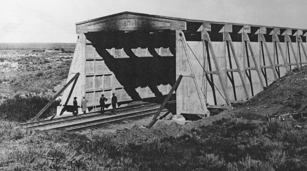
Fig. 11 – The Rock River snow shed was large enough to accommodate two trains, each a mile long. Fee and Murphy Collection, American Heritage Center, University of Wyoming
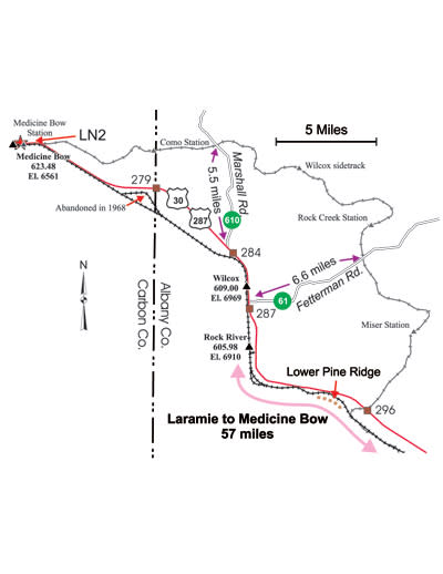
Map 12 – Lower Pine Ridge to Medicine Bow
Stop LN2 – Medicine Bow. The Virginian Hotel and the railroad station, now a museum, were built in 1912 and 1913, respectively. Medicine Bow was home to Owen Wister’s novel, “The Virginian,” which is often considered the world’s first western novel. It spawned a multitude of other novels as well as dozens of movies and television shows.
Follow U.S. 30/287 back towards Laramie. Just south of Bosler take a left (east) on Wyoming highway 34 and drive for .5 miles. Note the old railroad boxcars, converted to bunk cars, which are now used as storage by a rancher (see Map 10 on page 17) [GPS].
Return to U.S. 30/287 and follow it to Laramie. Note that the present railroad passes over gently rolling hills for most of the trip, necessitating several substantial cuts and fills. The original roadbed required considerably less earth moving, but was three miles longer.
Other Railroads in Albany County
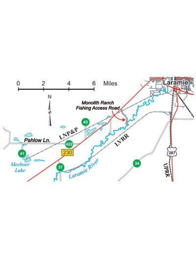
LNP&P. The Laramie North Park and Pacific built southwest from Laramie to the Union Pacific Soda Lakes (now Meeboer and Gelatt Lakes) in 1880. (See Map 13 on page 22.) The line, which carried soda (sodium carbonate) to a glass plant in Laramie, lasted only until 1901, at which time the tracks were removed. Traces of its roadbed are visible where they cross Wyoming 230 and County Roads 43 and 422. The roadbed now disappears into Meeboer Lake.
LVRR. The Laramie Valley Railroad was constructed in 1927 and continued operations until the early 1980s. It paralleled the LNP&P and led to a quarry that serviced the cement plant south of Laramie.
Fig. 12 – Laramie Valley RR engine 4455 in 1967. Jerry Hansen Collection
DL&NW. The Denver Laramie and Northwestern originally hoped to reach from Denver to Seattle via Laramie. Its tracks only made it to Greeley, CO, but they did some grading that reached into southern Albany County (on the Wyoming/Colorado border, three miles west of U.S. 287).
Trolleys. Prior to 1900 there were plans to build a trolley line in Laramie. Some tracks were laid in the downtown, but no trolleys were ever run.
Map 13 – LNP&P and LVRR
Laramie, Hahns Peak and Pacific (LH)
The Laramie, Hahns Peak & Pacific Railway was incorporated in 1901 by Isaac Van Horn of Boston and Fred A. Miller of Laramie. It was part of a syndicate of companies under the general banner Boswyocolo (for Boston, Wyoming, Colorado). The line was originally intended to stretch to the gold mines at Gold Hill in the Medicine Bow Mountains to the west, but by the time it arrived the mines had been worked out, so they decided to turn the route south towards North Park in Colorado. The syndicate owning the railroad also operated coal mines in this region. In late 1911 it entered Coalmont, Colorado, 26 miles southwest of Walden, extending the line a total of 111 miles.
Laramie functioned as the main terminal for the LHP&P. Emblazoned on its engine tenders and freight cars was the slogan, “Laramie Plains Line.”
Drive to the Spiegelberg Lumber and Building Company cabinet shop west of Cedar Street on University Avenue.
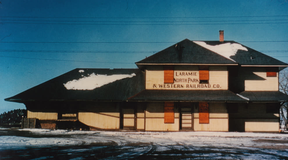
Fig. 13 – LNP&W (originally LHP&P) Fremont Street station, ca. 1951. Jerry Hansen Collection
A passenger depot, coal bunker, and engine house were built here, but only the engine house remains and is used as a cabinet shop for the Spiegelberg Lumber & Building Company. LHP&P’s attractive depot was a block to the north.
The LHP&P went into receivership soon after reaching Coalmont, CO., and then underwent an extended period of reorganizations and name changes:
1901 – 1914 Laramie, Hahns Peak & Pacific
1914 – 1924 Colorado, Wyoming & Eastern
1924 – 1924 Northern Colorado & Eastern
1924 – 1951 Laramie, North Park & Western
1951 – 1986 Union Pacific’s Coalmont Branch
1986 – 1996 Wyoming Colorado RR (WYCO)
WYCO operated it as a tourist line before ceasing operations in 1996. The track was removed a few years later. Most of the roadbed is still intact, however, and a substantial portion of it has been converted to a wonderful hiking, biking, and equestrian trail through the Medicine Bow National Forest.
Drive west on Snowy Range Road and follow Wyoming 130 toward Centennial. Zero your odometer where Wyo. 130 and 230 diverge in West Laramie.
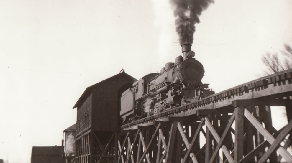
Fig. 14 – LNP&W engine 8 backing coal cars into the Laramie coaling facility, ca. 1930s.
Jerry Hansen Collection
The abandoned LHP&P roadbed is just north of the highway for much of the route to Centennial.
MM 6 to MM 14 – Big Hollow. To your south is the Big Hollow, the largest deflation feature in North America. Unlike most valleys, which are carved by water, this one was created by the wind, an example of aeolian erosion.
MM 9 – Overland Trail Crossing. Stop at the Roadside Interpretive Area of the Overland Trail to read the historic marker [GPS].
Continue west on Wyoming 130 to Mandel Lane (CR 57) and turn right (north) onto the county road. See map 14.
Stop LH1 – Hatton. Park at the public fishing access lot and take a short hike west along the abandoned railroad to a trestle over the Little Laramie River [GPS]. There was a water tower 200 to 300 feet west of the trestle and its foundation is still intact, but the overgrown vegetation makes access difficult.
Continue along Millbrook Road to Wyoming 130 and make a right (west) toward Centennial.
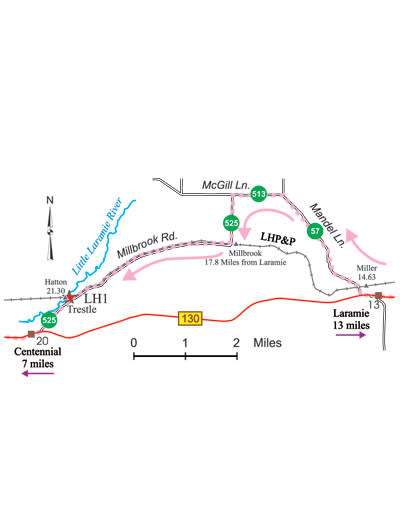
Map 14 – LNP&P at Hatton and vicinity
Stop LH2 – Nici Self Museum. This is a lovely place to visit. The depot was built in 1907 and is listed on the National Register of Historic Places. It has been lovingly restored and painted in its original colors. The depot was originally located 500 feet to the west.
Stop LH3 – Mountain View Hotel. This building was built by the LHP&P in 1907 and is also listed on the National Register.
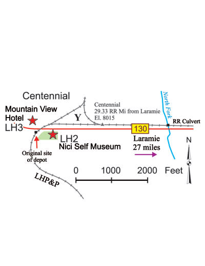
Map 15 – LNP&P near Centennial
Backtrack on Wyoming 130 east toward Laramie for a little under six miles to Wyoming Highway 11. Follow Wyoming 11 south toward Albany for about 10 miles.
At this point, the railroad begins climbing the Medicine Bow Mountains via an incredible series of “muleshoe” curves (see Map 16 on page 26). From here to the Dry Park Trailhead it rises approximately 700 feet in a straight line distance of 1.4 miles, but the spaghetti-like track arrangement consumes a railroad distance of 7 miles, so the resulting average grade is a hefty, but manageable, 2%. At one place the railroad travels 1.3 miles around a loop, ending up 300 feet away from where it began, but 140 feet higher in elevation. While this series of muleshoe curves substantially reduced the track’s grade, it did not come easily. Trains were required to negotiate sharp 12 degree curves in order to accomplish this feat.
Continue on another .5 miles to the parking area in Albany.
Stop LH4 – Albany. Note the high fill and the scar on the nearby hillside [GPS]. The fill was originally a trestle and the scar was a borrow pit for the fill. The roadbed on this loop is on public land and makes for an enjoyable .7 mile hike.
About 900 feet further along the Forest Service road is yet another railroad crossing, making three crossings of the same railroad in under a mile.
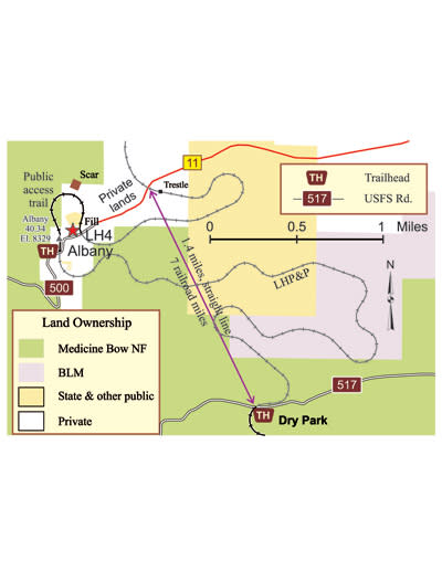
Map 16 – Railroad curves at Albany
Head back toward Centennial and drive for 2.5 miles to Fox Creek Road (CR 47). Make a right onto the county road and drive another 1.6 miles to its junction with FS 517, Dry Park Road. Take the Forest Service road for about two miles to the Dry Park Trailhead. This is the north end of the Rail/Trail.
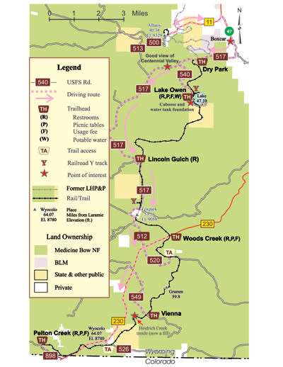
Map 17 – Rail Trail in Medicine Bow National Forest
Rail Trail in the Medicine Bow Mountains
This trail is limited to hikers, cyclists, and equestrians. It extends from the Dry Park Trailhead south to the Pelton Creek Trailhead, a distance of 21 miles through the beautiful Medicine Bow National Forest. Wildlife, including antelope, moose, deer, and beaver are common sights along the trail. The Forest Service has erected interpretive signage about the railroad at several strategic locations and there are mileposts, marking the original railroad miles from Laramie, along the full extent of the trail. Restrooms are available at most trailheads; the Lake Owen Trailhead has potable water. A caboose, and nearby railroad Y and water tank foundations [GPS] make this an especially desirable place to spend some time.
Refer to Map 17 on page 27 for a suggested driving route: From the Dry Park trailhead, follow FS 517 and FS 512 to Wyoming 230, and then drive south to the Wyoming/Colorado border. Just south of the border, FS 898 leads to the Pelton Creek trailhead. Side trips to other trailheads and Rail/Trail access points are also shown on the map.
From the Pelton Creek Trailhead, the railroad originally ran another 43.5 miles to Coalmont, CO, at Milepost 111. By the mid-1960s that had been cut back to Hebron, CO, at Milepost 108. In the mid-1990s, while under WYCO ownership, freight trains regularly ran to Walden, CO, located at Milepost 92, while their tourist trains stopped at Foxpark. Now only ghost trains ride these phantom rails.
We hope you have enjoyed your tour of the railroads of Albany County.
For more information about the railroads of Albany County, visit the Laramie Railroad Depot Association website: www.laramiedepot.org.
Table of GPS Coordinates
GPS Coordinates for Selected Features, WGS84
Features marked with (P) are on private land – DO NOT TRESPASS
Map Feature Lat. (N) Long. (W)
4 Stop SH1, remnant cut/fill 41o, 5’, 59” 105 o, 8’, 38”
4 Stop SH2, Gangplank view 41 o, 6’, 0” 105 o, 9’, 20”
– View of fill shown in Figure 4 41 o, 5’, 56” 105 o, 9’, 40”
5 Stop SH3, Buford orig. RR grade 41 o, 7’, 24” 105 o, 18’, 1”
6 Sherman turntable (P) 41 o, 7’, 59” 105 o, 23’, 49”
6 Sherman cemetery 41 o, 8’, 8” 105 o, 24’, 2”
6 Stop SH6, Reed’s Rock (P) 41 o, 7’, 55” 105 o, 24’, 32”
7 View of The Fill 41 o, 6’, 37” 105 o, 23’, 8”
7 View of The Fill 41 o, 6’, 24” 105 o, 23’, 10”
7 Stop P2, view of Track 3 41 o, 4’, 39” 105 o, 23’, 25”
7 Stop P3, view of Track 3 41 o, 4’, 24” 105 o, 23’, 3”
7 Old boxcars (P) 41 o, 4’, 13” 105 o, 21’, 46”
8 Stop SH7, view of Dale Cr. gorge 41 o, 6’, 53” 105 o, 28’, 5”
8 Stop SH8, old Tie Siding (P) 41 o, 5’, 30” 105 o, 29’, 20”
9 Stop SH10, aluminum plant (P) 41 o, 15’, 51” 105 o, 36’, 13”
9 Stop SH10, Mountain Cement (P) 41 o, 16’, 7” 105 o, 36’, 9”
– Former U.P. stock yards (P) 41 o, 19’, 47” 105 o, 35’, 49”
– Former PFE icing plant (P) 41 o, 20’, 33” 105 o, 35’, 58”
10 Stop LN1, Wyoming station 41 o, 28’, 9” 105 o, 43’, 41”
10 Remnant siding (P) 41 o, 32’, 38” 105 o, 43’, 5”
10 Old boxcars (P) 41 o, 33’, 27” 105 o, 40’, 26”
11 Lookout siding (P) 41 o, 39’, 59” 105 o, 48’, 9”
12 Original UPRR crosses U.S. 30/287 41 o, 42’, 33” 105 o, 52’, 16”
13 LNP&P crosses WY 230 41 o, 16’, 6” 105 o, 41’, 9”
– Overland Trail crosses WY 130 41 o, 18’, 41” 105 o, 48’, 4”
14 Stop LH1, Hatton trestle 41 o, 18’, 19” 105 o, 58’, 56”
15 LHP&P culvert (P) 41 o, 17’, 51” 106 o, 7’, 30”
16 LHP&P trestle (P) 41 o, 11’, 19” 106 o, 7’, 18”
16 Albany Fill 41 o, 11’, 15” 106 o, 7’, 47”
16 Scar (borrow pit for fill) 41 o, 11’, 20” 106 o, 7’, 49”
17 Boxcar (P) 41 o, 10’, 54” 106 o, 4’, 48”
17 Lake water tower foundation 41 o, 8’, 48” 106 o, 6’, 33”
17 Heidrich Creek trestle (now a fill) 41 o, 1’, 15” 106 o, 9’, 11”


