Hiking

Hiking

Alpine lakes, high peaks, and brilliant wildflowers await the intrepid hiker just outside of Laramie. The Snowy Range Mountains offer rugged scenery while Vedauwoo features wild granite hoodoo formations. Experienced locals at Laramie outdoor shops can help outfit you for your next adventure.

Choose your

Hike

6 Tips For Backpacking

For the experienced and inexperienced alike, the outdoors surrounding Laramie, Wyoming offer an abundance of backpacking opportunities. 

Backpacking In The Snowy Range Mountains

The Snowy Range Mountains are a true gem of southeastern Wyoming. Shaped by a rich glacial history, the high alpine scenery of this range is stunning and boasts over 100...

Happy Jack & Pole Mountain

Found off of exit 323 on I-80 east of Laramie, Happy Jack is a wonderful area for hiking, camping, mountain biking, cross-country skiing, snowshoeing and even home to...

Medicine Bow Rail Trail

The Medicine Bow Rail Trail meanders through the heart of the Medicine Bow National Forest, 35 miles west of Laramie. It stretches 22 miles between the northern trailhead...

Pilot Hill

The Pilot Hill Project was a land swap completed in 2020 to connect the City of Laramie’s foothills directly to the 65,000 acres of National Forest to the east....

Snowy Range Mountains

The Snowy Range Mountains are a true gem of southeastern Wyoming. Shaped by a rich glacial history, the high alpine scenery of this range is stunning and boasts over 100...

Vedauwoo

Located 10 minutes east of Laramie, along I-80 are the towering rocks of Vedauwoo (pronounced “vee-dah-voo”). The name is derived from an Arapaho word meaning...

Trail Running

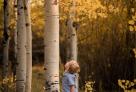
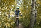
Home to an abundance of trails, the Laramie area offers unrivaled opportunities for trail users of all kinds. Many love to visit to hike or mountain bike, but up here...

Hiking In The Medicine Bow National Forest

11-Snowy_Range_Hiking.
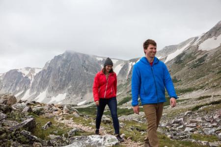
Located 20 minutes west of Laramie, the Snowy Range Mountains earn their name. With peaks and valleys between 9,000 and 12,000 ft., come prepared for snow any time of year.

Wyoming Highway 130, the Snowy Range Scenic Byway, provides access during the summer months but is closed during the winter and early spring. Campgrounds, picnic areas, and trailheads abound along this scenic 100-mile stretch of road.

The Snowy Range features many hikes and climbs. Medicine Bow Peak is the highest point in southern Wyoming and a challenging four-mile trail leads to the 12,013 ft. summit. Libby Creek Trail and Lakes Trail are popular hikes with both visitors and locals alike.

Hiking At Vedauwoo

vedauwoo Sunset
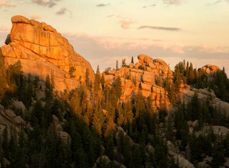
Incredible granite hoodoo formations along with pine and aspen groves provide a haven for hikers and trail runners in the Vedauwoo (pronounced VEE-da-voo) area, a 20 minute drive southeast of Laramie. Many trails permit travel by horseback, which can ease the burden of a multi-day expedition. Slick vertical paths reach the summits of Vedauwoo, while gentler trails meander in the forest. The three mile Turtle Rock Loop and the Box Canyon Trail to the summit of Glen Dome are the most popular hikes in this region. Wildlife sightings are common, so watch for beavers, pronghorn antelope, raptors, elk, and moose as you hike.

Vedauwoo is derived from the Arapaho word “bito'o'wu” meaning “earth-born.” The characteristic hoodoos and outcrops of this region are made of 1.4 billion-year-old Sherman Granite, some of the oldest rock in Wyoming, still a billion years younger than the Tetons. The fabulous formations are due to an uplift of the Laramie Mountains that began about 70 million years ago, along with the erosion of younger layers of rock and sediment, which continues to this day.

Important Information

  • No permits are needed to hike in the Snowy Range or Vedauwoo area.
  • Please follow “Leave No Trace” guidelines to keep this area beautiful for future generations.
  • Parking in day use areas and at trailheads requires a modest fee. Interagency annual, senior, and access passes are accepted.
  • Off-road travel by motorized vehicles is prohibited in this area.
  • Dogs must be kept on a leash in the day use areas, at trailheads or in campgrounds.
  • Mountain weather is unpredictable! Be sure to check a forecast before you depart.

BACKCOUNTRY CHECKLIST

  • Map & Compass
  • Flashlight
  • Extra Food, Water & Clothing
  • Sunglasses & Sunscreen
  • First-aid Kit
  • Pocket Knife
  • Waterproof Matches
  • Whistle
  • Insect Repellant
  • Pepper spray (especially in bear country)
  • Rain Gear
  • Water Purifier

Experienced locals at Laramie outdoor stores can help outfit you for your hike.

FOREST SERVICE INFORMATION

2468 Jackson Street Laramie, WY 82070-6535
Phone:
 (307) 745-2300 TDD Phone: (307) 745-2307 Fax: (307) 745-2398
Hours: 8 a.m. – 5 p.m., Monday – Friday (8 a.m. – 4:30 p.m. during winter)
The Supervisor’s Office and Laramie Ranger District office are located in the same building.

Maps

Forest Service Visitor Maps
Snowy Range
Vedauwoo
Camping 
Libby Creek Trail 
Medicine Bow Peak Trail 
Turtle Rock Trail

You May Also Like

You May Also Like

1). Q: Is there hiking near Laramie?
 
A: There are several great places where you can escape from the city for a hike. The selection of hikes in the region ranges from flat, easy walks to more challenging hikes with a steep vertical incline. There are also excellent routes for trail running. The Snowy Mountain Range, Vedauwoo, Pilot Hill, Happy Jack and Pole Mountain are just a few of the more popular spots that offer a good selection of hiking and backpacking trails for all abilities.
 
2). Q: What are the best hikes in the Snowy Range Mountains?
 
A: The Snowy Range Mountains are 35 miles west of Laramie in the Medicine Bow National Forest. Hiking trails in “The Snowies” are plentiful, with easy terrain for beginner-level hikers and difficult trails for more advanced hikers. Two Medicine Bow Peak Trails lead to the top of Medicine Bow Peak, the highest in southern Wyoming at 12,013 feet. Libby Creek Trail near Centennial is another easy hike that’s a local favorite. For more of a challenge, try the moderate-rated Gap Lakes Trail.
 
3). Q: Can I hike at Vedauwoo?
 
A: Vedauwoo is one of Wyoming’s best locations for bouldering and hiking. The area is made up of a towering pile of rocks, so it’s perfect for challenging hikes and crack climbs. Vedauwoo has more than 800 recognized routes - short and long, easy or difficult. Take your pick!
 
4). Q: Where is the Pilot Hill Project?
 
A: The Pilot Hill Project spans 9 square miles and connects the foothills near Laramie to the National Forest to the east, making it simple to reach Pole Mountain and Happy Jack Recreation Area without the use of the interstate. The Pilot Hill Project protects vital open space and critical natural wildlife habitat. The project has just launched and will be further developed over the next few years to maximize the outstanding cycling, hiking, and equestrian opportunities for visitors.  
 
5). Q: How long is the Medicine Bow Rail Trail?
 
A: Located 35 miles west of Laramie in the heart of Medicine Bow National Forest, the rail trail is 22 miles long, from the northern trailhead (Dry Park) to the southern trailhead (Pelton Creek). The trail has a total of six trailheads: Dry Park, Lake Owen, Lincoln Gulch, Woods Creek, Vienna, and Pelton Creek (from north to south). There are campgrounds at Lake Owen and Pelton Creek. Restrooms are located at four trailheads: Lake Owen, Lincoln Gulch, Woods Creek, and Pelton Creek. 
 
6). Q: Can I hike Pole Mountain?
 
A: Pole Mountain Open Space has excellent day hikes and a nice area for backpacking across its 55,000 acres. A few of the more popular hikes are the Tie City Trailhead, Happy Jack Trailhead, Laramie Ranger District and Blair Picnic Site. At Vedauwoo, the campground and picnic sites both have good hikes that can be accomplished in a day (or less). The Laramie Ranger District is also a prime starting point for overnight backpacking. 
 
7). Q: What is there to do at Happy Jack?
 
A: Located east of Laramie, Happy Jack presents top-notch hiking trails, mountain biking, horseback riding, and camping during the warmer months. It’s also a popular destination during the winter for groomed cross-country skiing and snowshoeing. The interlacing trails range from about a half-mile to over 3 miles in length. Wildlife is abundant, and you may encounter beavers, black bears, moose and white-tail deer. Happy Jack has two campgrounds: Tie City Campground and Yellow Pine Campground. 
 
8). Q: Where is the best trail running near Laramie?
 
A: The Schoolyard Trail System serves up 20 miles of running trails near Laramie. The 2.5-mile Jacoby Ridge Trail is a short loop that is wide enough for a tandem or a jogging stroller. There are miles of varying trails at Vedauwoo (about 25 total miles of trails), Happy Jack (roughly 25 miles), and Curt Gowdy State Park (about 25 miles). Located near Woods Landing and 30 minutes from Laramie, the flat Medicine Bow Rail Trail covers roughly 25 miles.
 
9). Q: Where is the best place for an overnight backpacking trip near Laramie?
 
A: Head to the Snowy Range Mountains for awesome overnight backpacking adventures. The Browns Peak Loop is a 12.5-mile loop that meanders along four distinct lakes and has magnificent mountain views. It’s easy and beautiful, simply put. The 14.9-mile Deep Creek/Rock Creek Trail is a moderate-rated out-and-back with a steep incline (about 2,000 feet), narrow sections and some loose rock to navigate. Sheep Mountain Trail is a 12.6-mile trek with 1,300 feet of climb in the first 3.5 miles. A lesser-traveled route, the trail has a beautiful wide basin at the top with fascinating wildflowers and an unbelievable view.
 
10). Q: What is the best hike in the Medicine Bow National Forest?
 
A: The Turtle Rock Trail is without a doubt the most popular hike in the first. The 3.1-mile trail begins at the trailhead, just above the roundabout near the campground and Box Canyon. From there, you start the journey through a beautiful aspen grove. There are some rock sections, but most of it is easy and beginner-friendly; mostly decomposed granite with some rock sections on the northeast side. 
 
11). Q: Is Vedauwoo worth it?
 
A: Vedauwoo is derived from an Arapaho word that means “earth-born.” The awesome granite hoodoos and outcrops of this region are made of 1.4 billion-year-old Sherman Granite, some of the oldest rock in Wyoming. The exquisite formations - along with stunning aspen groves and pine forests - provide a perfect destination for hiking, exploring, photography, or just soaking up fresh air and sunshine. It’s an ideal day trip from Laramie. If you’re up for a return trip, consider camping and traveling by horseback. 
 
12). Q: Do I need a permit?
 
A: No permits are required to hike in the Snowy Range Mountains or Vedauwoo. Parking in day-use areas and at trailheads may require a nominal fee. Interagency annual, senior, and access passes are accepted. No offroad travel by motorized vehicles is allowed. Both the mountains and Vedauwoo do follow a “Leave No Trace” policy to keep the region pristine for future generations to enjoy. 
 
13). Q: Are there dog-friendly hikes near Laramie?
 
A: Dogs must be kept on their leash in the day-use areas, at the trailheads, and in the campgrounds. There are a few trails that are perfect for your four-legged companion. The Medicine Bow Peak Trail begins at Lewis Lake and climbs more than 12,000 feet to the peak. The Browns Peak Loop in the Snowy Range Mountains is an easy-to-moderate 13-mile route. 
 
14). Q: Does it cost to park my vehicle?
 
A: If you want to park your vehicle in the day-use areas or at the trailheads, you may be required to pay a small fee. If you have an interagency, senior, or access pass, it can be used. No permits are required. 
 
15). Q: What do I need for a backcountry hike?
 
A: Before you head out for an amazing overnight backpacking trip, you’ll need to be prepared. Be sure to pack all the maps you’ll need, along with a compass and a flashlight. Pack extra food, water, clothing, sunglasses, sunscreen and a pocket knife. Remember to bring along a First Aid kit in case of an emergency and rain gear, a water purifier, and waterproof matches are always a good idea. A whistle is good to draw attention to yourself or scare off wildlife, and insect repellant is a must! Since this is bear country, consider pepper spray as an added protective measure. If you forget anything, stop by one of the outdoor stores in Laramie and get what you need. 
 
16). Q: Where can I find area hiking maps?
 
A: If you’re looking for hiking trail maps, you’re in luck. At VisitLaramie.org, you can view and download Forest Service Visitor Maps, along with maps for the Snowy Range, Vedauwoo, Libby Creek Trail, Medicine Bow Peak Trail, and Turtle Rock Trail. There is also a useful map of camping locations. All maps are free to download and print.